Baile Herculane - Day 1
THIS LAST WEEKEND WAS INCREDIBLE! I told everyone I was going to Baile Herculane with the base MWR but two days before, it was cancelled because of a lack of interest - not mine!!! So with the help of a couple other civilian friends I've made, we got with MWR and signed out a van to charge out on our own. So Saturday morning the five of us got in the van (I drove all weekend) and we set out for Baile Herculane, about 224km away. It was Me, Carol, Maria, Paul, and his wife - our gracious Romanian translator.
Baile Herculane
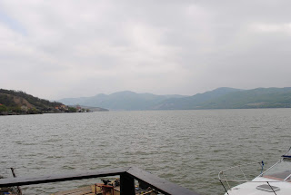
My first look at the beautiful blue Danube River. Looking out over the water, Serbia is on the other shore. I haven't been to Serbia since my days in Sarajevo when I served proudly with the men and women at the NATO AFSOUTH Headquarters.
Our Romanian aquatic chauffeur (Sorin) and tour guide (who spoke no English).
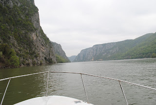
And we're on our way, it was an overcast day but that didn't have any effect on the excitement. The boat captain was a lifetime resident of the area and told us all about the area and how this part of the river is called the "Iron Gates" due to it being the two thinnest parts of the river.
Our first sighting was a nearly 2000 year old carving on the mountainside. Sorin told us how this used to be 50 meters lower on the cliff but when they were building the dams, the area would be flooded and this treasure would be lost forever. Instead, the Romanians careful cut the carving out of the cliff and relocated to an area above what would be the new water level. This inscription is called Tabula Traiana. It is a Latin carving dedicated to the Roman Emperor Traian. As part of the operations against the Dacians (ancient Romanians), Traian constructed a road from Belgrade through the Iron Gates Gorge, up to the area where he constructed a bridge over the Danube (Traian's Bridge). He finished the road in 103 AD. East of the Great Cazane, the Roman emperor Trajan built the legendary bridge erected by Apollodorus of Damascus. Construction of the bridge ran from 103 through 105 AD, preceding Trajan's final conquest of Dacia.
The inscription on the structure states:
Caesar, the Emperor, the Son of Goddess Nerva, Traian Augustus Germanicus, the Supreme Priest, the Representative of People for the Forth Time, Having Conquered the Rocks of the Mountains and the Danube, is now Constructing this Road.
The Iron Gates is a gorge on the river Danube forming part of the boundary between Serbia (to the south) and Romania (to the north). It encompasses a route of 134 km (83 mi); but in reality it only encompasses the last barrier on this route, just beyond the Romanian city of Orșova. This stretch of the Danube containing two hydroelectric dams, with two power stations, Iron Gate I Hydroelectric Power Station and Iron Gate II Hydroelectric Power Station.
At this point in the Danube, the river separates the southern Carpathian Mountains from the northwestern foothills of the Balkan Mountains. The Romanian side of the gorge constitutes the Iron Gates natural park, whereas the Serbian part constitutes the Đerdap national park.
Sandstone statues discovered here dated to the early neolithic era indicating the area has been inhabited for a very long time. Even more significant are the Iron Gates mesolithic (13,000 to 5,000 years) sites, particularly the gorge of Gospodjin Vir, which contains the major archaeological site of Lepenski Vir (unearthed in the 1960s). LepenskiVir is often regarded as the most important mesolithic site in south-east Europe.
The photo on the top is the Small Iron Gate - the thinnest, but deepest, part of the river. It is in this area during the reign of the Communists in Romania, many would try and escape by swimming across this passage. So many were escaping, the dictator Nicolae Ceausescu made the area a military camp to stop them. It didn't work though. On 27 November 1987, Nadia Comaneci, the Olympic gold medal winning gymnast, and five other Romanian defectors, swam across the Danube at this point and walked for miles before reaching the border of Hungary. Because she was famous, she was allowed entry and later into Austria and eventually her freedom in America.
Along the river there are three (two pictured because one is now gone) river traffic stations. These locations guided ships through the Iron Gates to prevent collisions after the dams were constructed. The one which is not pictured is under water now.
Mraconia Monastery
This quaint church was originally constructed either in 1453 or 1523, depends on who you ask. The original structure was completely destroyed during the Russian-Austrian-Turkish battles between 1787 and 1792. The ruins were discovered in 1823 and remained undeveloped. In 1931, the monastery began reconstruction. In 1967 though, with the building of the Iron Gate dams, it was in the path of the flood waters and became known as the "Monastery Under Water." The current structure was built in 1993 and some pieces of the original monasteries are on display inside.
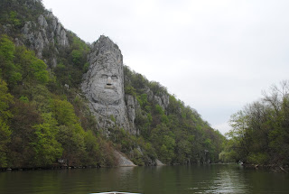
Our journey continued until we reached our feature destination - the Rock Sculpture of Decebalus
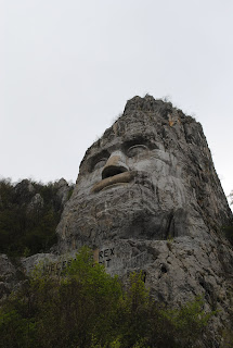
The rock sculpture of Decebalus is a 42.9 m in height and 31.6 m in width carving in rock of the face of Decebalus, the last king of Dacia from 87-106 AD, who fought against the Roman emperors Domitian and Trajan to preserve the independence of his country, which corresponded to modern Romania. The sculpture was made between 1994 and 2004, on a rocky outcrop on the river Danube, at the Iron Gates, which form the border between Romania and Serbia. It is located near the city of Orșovain Romania. It is the tallest rock relief in Europe. It is bigger than the Statue of Liberty and the Monument of Christ in Rio de Janeiro in Brazil.
It was commissioned by Romanian businessman Iosif Constantin Drăganand it took 10 years, from 1994 to 2004, for twelve sculptors to finish it. Drăgan purchased the rock in 1993, after which the Italian sculptor Mario Galeotti assessed the location and made an initial model. The first six years involved dynamiting the rock into the basic shape, and the remaining four years were devoted to completing the detail.
Under the face of Decebalus there is a Latin inscription which reads "DECEBALUS REX—DRAGAN FECIT" ("King Decebalus—Made by Drăgan"). The carving was placed opposite the ancient memorial plaque, carved in the rock on the Serbian side of the river facing Romania which I talked about earlier. The plaque, known as the Tabula Traiana, records the completion of Trajan's military road along the Danube and thus commemorates the final defeat of Decebalus by Trajan in 105, and the absorption of the Dacian kingdom into the Roman Empire. Drăgan wanted the Serbs to carve a giant head of a Roman Emperor, as if confronting Decebalus on the opposite side of the river, but the Serbs refused.
Drăgan was a leading figure in the protochronism movement, a nationalist ideology which attempted to portray Romania as the major cradle of civilization and which identified Romania with an ancient Thracian empire which supposedly dominated central Europe. In this ideology, Dacia, the pre-Roman name of Romania, was the inheritor of this Thracian culture.
It was an awesome experience to sail under the face of this Dacian giant.
Now we had to turn around and head back to the port, but we weren't finished just yet. On the way back, our guide took us to another spot only accessible by boat. It is known as "Veteran's Cave." This cave was the first cave charted in Europe and has been inhabited by humans since ancient times, approximately 3500 years ago. It was initially used to shelter humans and animals from the weather.
The Dacians used to worship the god Zamolxis on an alter inside the cave. They would bring birds in to be sacrificed to the gods because, in the morning, after sunrise, the rays penetrate a natural opening and the light would fall directly on the alter.
During the 18th century, the fierce Ottoman Empire on one side of the river and the Austro-Hungarian Empire on the other. This was a great strategic point from which to defend the Danube.
Here too you can see the remains of what was once the General's Room. The army fought from this position, firing a cannon through the opening at their enemies. When the Turks conquered Budapest in 1830 though, the Austrians were forced to leave the cave. Inside the cave you can see where they dug a well for water and used passages to move about the inside of the mountain.
Adjacent to the Veteran's Cave is a living natural monument protected by law which you can only find in this one location on Earth - The Yellow Tulips of Cazane.
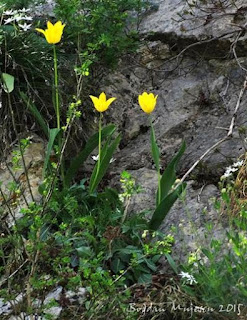 |
| Stock photo (I couldn't get close enough) |
The species was discovered in 1882 on the cliffs of the Romanian Great Cazane. Two years later, a Serbian scientist discovered them on the Serbian coast at an inaccessible peak (how'd he get there if it's inaccessible?). The sole Serbian tulip disappeared in 1940. The flower blooms in April and May and we were lucky enough to see them in full bloom!
One last stop before we headed back to the dock to dine on some great Danube seafood was the Danube Grotto. A series of caves our guide told us goes for hundreds of kilometers beneath these lower Carpathian foothills.
We didn't have time to disembark because everyone was famished after sailing for hours on this small part of the beautiful Danube River so we left this for another time. It was fantastic just to see it.
Well, it's off to a dinner of fried sturgeon and polenta and to check in to our Pensione. More updates tomorrow.










No comments:
Post a Comment